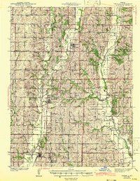
1943 Map of Parnell
USGS Topo · Published 1943About this map
Parnell serves as a central hub for agricultural commerce in Nodaway County during the early 1940s, situated at the intersection of the Chicago Great Western railroad and the Great Western Highway. This survey reveals a remarkably dense network of rural infrastructure, where nearly every section of land is anchored by a local schoolhouse or church. Unique social markers like Common Sense Sch and Common Sense Cem sit near Orrsburg, while the southern reaches are dominated by the significant religious complex of St Benedict Convent at Clyde.
Find a feature on this map
62 named features on this map. Tap any name to fly to it.
Don’t see what you’re looking for? This feature index may not catch every label — zoom into the map to look around manually.
Map Details
Editions of this 1943 Parnell Map
2 editions found

Other maps of this area

1925 · Stanberry
USGS Topo · 1:62,500

1925 · Darlington
USGS Topo · 1:62,500

1927 · Bolckow
USGS Topo · 1:62,500

1939 · Stanberry
USGS Topo · 1:62,500

1940 · Blockton
USGS Topo · 1:62,500

1940 · Bedford
USGS Topo · 1:62,500

1940 · New Market
USGS Topo · 1:62,500

1940 · Parnell
USGS Topo · 1:62,500

1942 · Grant City
USGS Topo · 1:62,500

1943 · Bedford
USGS Topo · 1:62,500