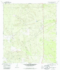
1968 Map of Parrilla Creek SW
USGS Topo · Published 1986About this map
Solo Ranch stands as a focal point of human habitation in this arid expanse of Duval County, where the management of water defines the landscape. The 1968 survey illustrates a complex network of ranching infrastructure, characterized by numerous windmills with distinctive names such as Javalina Windmill, Callejon Windmill, and Artesian Pen Windmill. These structures, alongside man-made reservoirs like Valders Tank and Leona Tank, highlight the necessity of groundwater for sustaining life and livestock between the ephemeral flows of Agua Poquita Creek and Macho Creek. Beyond the ranching economy, the map documents an active energy landscape, with numerous oil wells and a pumping sta indicating the industrial extraction of petroleum. The presence of multiple gravel pits further underscores a terrain heavily utilized for its natural resources during the late 1960s.
Find a feature on this map
28 named features on this map. Tap any name to fly to it.
Don’t see what you’re looking for? This feature index may not catch every label — zoom into the map to look around manually.
Map Details
Editions of this 1968 Parrilla Creek SW Map
2 editions found
Other maps of this area

1939 · Bruni
USGS Topo · 1:62,500

1956 · Laredo
USGS Topo · 1:250,000

1967 · Parrilla Creek SE
USGS Topo · 1:24,000

1967 · Realitos
USGS Topo · 1:24,000

1967 · Hebbronville NW
USGS Topo · 1:24,000

1968 · Parrilla Creek SW
USGS Topo · 1:24,000

1968 · Mills Bennett
USGS Topo · 1:24,000

1968 · Parrilla Creek NW
USGS Topo · 1:24,000

1968 · Parrilla Creek NE
USGS Topo · 1:24,000

1968 · San Pablo
USGS Topo · 1:24,000