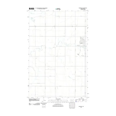
2011 Map of Parshall
USGS Topo · Published 2011About this map
Parshall serves as the primary hub of activity in this section of Mountrail County, organized around a geometric grid that stands in sharp contrast to the wandering paths of the local waterways. The community is anchored by local landmarks such as Hankins Field and the Parshall Cemetery, which lie on the southern outskirts of the developed town site. The surrounding landscape is defined by the drainage patterns of Shell Creek and the East Fork Shell Creek, which meander through the prairie.
Find a feature on this map
21 named features on this map. Tap any name to fly to it.
Don’t see what you’re looking for? This feature index may not catch every label — zoom into the map to look around manually.
Map Details
Editions of this 2011 Parshall Map
This is the sole edition of this map. No revisions or reprints were ever made.
Other maps of this area

1953 · Williston
USGS Topo · 1:250,000

1953 · Watford City
USGS Topo · 1:250,000

1957 · Williston
USGS Topo · 1:250,000

1957 · Watford City
USGS Topo · 1:250,000

1967 · Watford City
USGS Topo · 1:250,000
1967 · Parshall SE
USGS Topo · 1:24,000

1967 · Parshall SW
USGS Topo · 1:24,000

1967 · New Town SE
USGS Topo · 1:24,000
1981 · Parshall NE
USGS Topo · 1:24,000
1981 · Epworth SE
USGS Topo · 1:24,000