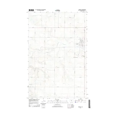
2014 Map of Parshall
USGS Topo · Published 2014About this map
Parshall serves as the primary hub of activity in this section of Mountrail County, organized around a traditional grid with Main St N and Main St S at its core. The town is situated just north of the East Fork Shell Creek, which meanders through the prairie landscape alongside its smaller namesake, Shell Cr. To the south of the residential and commercial district, the Parshall-Hankins Airport and the Parshall Cem flank the junction of ND-37 and local routes. This landscape reflects the systematic section-line road development typical of the region, where gravel and paved routes like 37th St NW and 75th Ave NW create a vast agricultural network. The southern edge of the map identifies McLean City Rd, marking the transition toward the neighboring county line.
Find a feature on this map
35 named features on this map. Tap any name to fly to it.
Don’t see what you’re looking for? This feature index may not catch every label — zoom into the map to look around manually.
Map Details
Editions of this 2014 Parshall Map
This is the sole edition of this map. No revisions or reprints were ever made.
Other maps of this area

1953 · Williston
USGS Topo · 1:250,000

1953 · Watford City
USGS Topo · 1:250,000

1957 · Williston
USGS Topo · 1:250,000

1957 · Watford City
USGS Topo · 1:250,000

1967 · Watford City
USGS Topo · 1:250,000
1967 · Parshall SE
USGS Topo · 1:24,000

1967 · Parshall SW
USGS Topo · 1:24,000

1967 · New Town SE
USGS Topo · 1:24,000
1981 · Parshall NE
USGS Topo · 1:24,000
1981 · Epworth SE
USGS Topo · 1:24,000