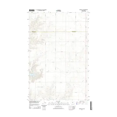
2014 Map of Parshall SW
USGS Topo · Published 2014About this map
Lake Sakakawea dominates the southwestern corner of this West River landscape, where the waters of the Missouri River reservoir extend into Lucky Mound Creek Bay. The terrain is characterized by the high, rolling plains of the Missouri Plateau, marked by a systematic grid of section-line roads such as 76th Ave NW and 25th St NW that define the agricultural character of the region. This 2014 survey documents the boundary line between Mountrail and McLean counties as it crosses the open prairie north of the lake. Toward the eastern edge, Nd 37 serves as the primary north-south transit corridor, connecting the remote farmsteads and rural infrastructure that punctuate this sparsely populated section of North Dakota.
Find a feature on this map
16 named features on this map. Tap any name to fly to it.
Don’t see what you’re looking for? This feature index may not catch every label — zoom into the map to look around manually.
Map Details
Editions of this 2014 Parshall SW Map
This is the sole edition of this map. No revisions or reprints were ever made.
Other maps of this area

1953 · Watford City
USGS Topo · 1:250,000

1957 · Watford City
USGS Topo · 1:250,000

1967 · Watford City
USGS Topo · 1:250,000

1967 · Raub NW
USGS Topo · 1:24,000

1967 · Raub
USGS Topo · 1:24,000
1967 · Parshall SE
USGS Topo · 1:24,000

1967 · Parshall SW
USGS Topo · 1:24,000

1967 · New Town SE
USGS Topo · 1:24,000
1970 · Saddle Butte
USGS Topo · 1:24,000
1981 · Parshall NE
USGS Topo · 1:24,000