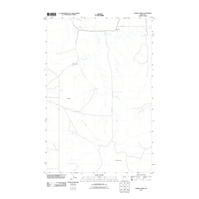
2011 Map of Parson Creek
USGS Topo · Published 2011About this map
Beehive sits in a high-plains landscape where the drainages of Parson Creek and Dry Creek meet in Richland County, Montana. This 2011 survey by the U.S. Geological Survey illustrates a sparsely populated ranching and agricultural region defined by ephemeral watercourses and local water management infrastructure. The map records specific points of irrigation or stock water control, such as Aluminum Dam near the northern boundary and Hamster Dam further south along a tributary of Parson Creek. To the southeast, the terrain rises toward the prominent elevation of Blue Mountain. The transportation network is built upon rural routes like County Rd 350 and Rte 261, which follow the natural contours of the stream valleys, reflecting the enduring patterns of movement in this part of eastern Montana.
Find a feature on this map
11 named features on this map. Tap any name to fly to it.
Don’t see what you’re looking for? This feature index may not catch every label — zoom into the map to look around manually.
Map Details
Editions of this 2011 Parson Creek Map
This is the sole edition of this map. No revisions or reprints were ever made.
Other maps of this area

1909 · Glendive
USGS Topo · 1:250,000

1954 · Glendive
USGS Topo · 1:250,000

1957 · Glendive
USGS Topo · 1:250,000

1958 · Glendive
USGS Topo · 1:250,000

1966 · Savage
USGS Topo · 1:24,000

1966 · Savage SE
USGS Topo · 1:24,000

1966 · Skaar NW
USGS Topo · 1:24,000
1974 · Skaar
USGS Topo · 1:24,000
1974 · Odland Dam NE
USGS Topo · 1:24,000
1974 · Skaar NE
USGS Topo · 1:24,000