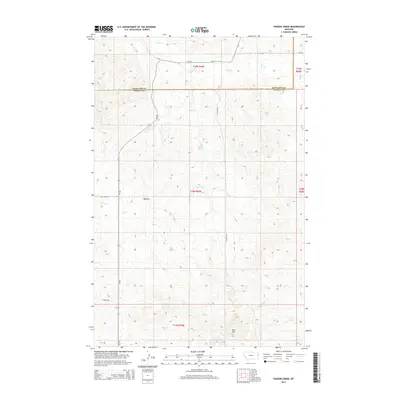
2014 Map of Parson Creek
USGS Topo · Published 2014About this map
Beehive sits along the western edge of this Eastern Montana landscape, where the high plains of Richland County meet the northern border of Wibaux County. The area is defined by a dendritic drainage system where Smith Cr and Parson Cr carve through the breaks, punctuated by vital water sources like Lady Brown Spring. To the south, the elevation rises toward the prominent landmark of Blue Mtn, which dominates the local topography. This 2014 survey documents the enduring rural infrastructure of the region, showing the convergence of primary routes like Mt-261 with established local tracks such as Dry Creek Rd and Lufboro Rd, reflecting a landscape dedicated to ranching and open-range navigation.
Find a feature on this map
19 named features on this map. Tap any name to fly to it.
Don’t see what you’re looking for? This feature index may not catch every label — zoom into the map to look around manually.
Map Details
Editions of this 2014 Parson Creek Map
This is the sole edition of this map. No revisions or reprints were ever made.
Other maps of this area

1909 · Glendive
USGS Topo · 1:250,000

1954 · Glendive
USGS Topo · 1:250,000

1957 · Glendive
USGS Topo · 1:250,000

1958 · Glendive
USGS Topo · 1:250,000

1966 · Savage
USGS Topo · 1:24,000

1966 · Savage SE
USGS Topo · 1:24,000

1966 · Skaar NW
USGS Topo · 1:24,000
1974 · Skaar
USGS Topo · 1:24,000
1974 · Odland Dam NE
USGS Topo · 1:24,000
1974 · Skaar NE
USGS Topo · 1:24,000