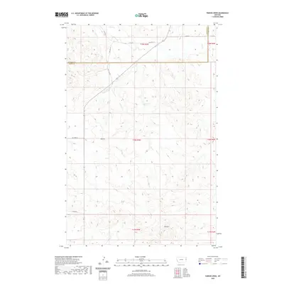
2020 Map of Parson Creek
USGS Topo · Published 2020About this map
Beehive sits at a geographic crossroads in the western portion of this Richland County landscape, where Dry Creek Rd meets the path of State Hwy 261. The terrain is defined by a series of drainages, most notably Parson Cr and Smith Cr, which carve through the high plains. In the southern reaches, the elevation rises toward the prominent landmark of Blue Mtn, while the seasonal flow of Dry Cr marks the central valley. A specific point of interest for those studying the local water table or early settlement patterns is Lady Brown Spring, a named water source located north of the Beehive area. The map also delineates the jurisdictional boundary between Richland Co and Wibaux Co, showing how local infrastructure like Lufboro Rd and Co Rd 101 connects these rural districts.
Find a feature on this map
19 named features on this map. Tap any name to fly to it.
Don’t see what you’re looking for? This feature index may not catch every label — zoom into the map to look around manually.
Map Details
Editions of this 2020 Parson Creek Map
This is the sole edition of this map. No revisions or reprints were ever made.
Other maps of this area

1909 · Glendive
USGS Topo · 1:250,000

1954 · Glendive
USGS Topo · 1:250,000

1957 · Glendive
USGS Topo · 1:250,000

1958 · Glendive
USGS Topo · 1:250,000

1966 · Savage
USGS Topo · 1:24,000

1966 · Savage SE
USGS Topo · 1:24,000

1966 · Skaar NW
USGS Topo · 1:24,000
1974 · Skaar
USGS Topo · 1:24,000
1974 · Odland Dam NE
USGS Topo · 1:24,000
1974 · Skaar NE
USGS Topo · 1:24,000