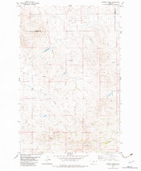
1982 Map of Parson Creek
USGS Topo · Published 1983About this map
Parson Creek and its drainage network define this reach of the Montana badlands, where the high prairie begins to break toward the Smith Creek valley. The landscape is characterized by intermittent water sources and high-ground landmarks such as Blue Mountain in the south and the Lady Brown Spring to the north. This 1980s-era topography shows a sparse ranching and agricultural environment straddling the boundary between Richland and Wibaux counties. Evidence of local habitation and early twentieth-century place-naming is concentrated around the Beehive vicinity. The map documents numerous wells and cattle tanks scattered across the draws and ridges, illustrating the essential infrastructure required for stock raising in this arid portion of eastern Montana.
Find a feature on this map
9 named features on this map. Tap any name to fly to it.
Don’t see what you’re looking for? This feature index may not catch every label — zoom into the map to look around manually.
Map Details
Editions of this 1982 Parson Creek Map
This is the sole edition of this map. No revisions or reprints were ever made.
Other maps of this area

1909 · Glendive
USGS Topo · 1:250,000

1954 · Glendive
USGS Topo · 1:250,000

1957 · Glendive
USGS Topo · 1:250,000

1958 · Glendive
USGS Topo · 1:250,000

1966 · Savage
USGS Topo · 1:24,000

1966 · Savage SE
USGS Topo · 1:24,000

1966 · Skaar NW
USGS Topo · 1:24,000
1974 · Skaar
USGS Topo · 1:24,000
1974 · Odland Dam NE
USGS Topo · 1:24,000
1974 · Skaar NE
USGS Topo · 1:24,000