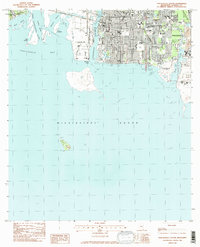
1982 Map of Pascagoula South
USGS Topo · Published 1982About this map
Pascagoula and Gautier appear at a moment of significant industrial and maritime activity along the Gulf Coast. The landscape is defined by the complex convergence of the West Pascagoula River, Middle River, and Pascagoula River as they empty into Pascagoula Bay. A massive Shipbuilding Plant dominates the western riverbank, signaling the area's deep ties to naval construction and maritime trade. The city grid is densely packed with community landmarks, including numerous educational institutions like Colmer Jr High Sch and St Peter Sch, reflecting a growing mid-century population.
Find a feature on this map
45 named features on this map. Tap any name to fly to it.
Don’t see what you’re looking for? This feature index may not catch every label — zoom into the map to look around manually.
Map Details
Editions of this 1982 Pascagoula South Map
2 editions found
Other maps of this area

1921 · Grand Bay
USGS Topo · 1:62,500

1921 · Petit Bois Island
USGS Topo · 1:62,500

1941 · Horn Island
USGS Topo · 1:62,500

1942 · Petit Bois Island
USGS Topo · 1:62,500

1942 · Horn Island
USGS Topo · 1:62,500

1943 · Pascagoula
USGS Topo · 1:62,500

1943 · Grand Bay
USGS Topo · 1:62,500

1953 · Mobile
USGS Topo · 1:250,000

1955 · Pascagoula
USGS Topo · 1:62,500

1957 · Mobile
USGS Topo · 1:250,000
Featured Places
- Pascagoula, MS
- Gautier, MS
- East Pascagoula, Pascagoula
- South Pascagoula, Pascagoula
- East Side, Pascagoula