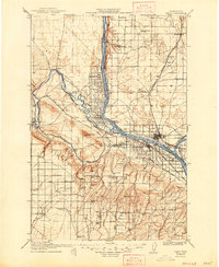
1917 Map of Pasco
USGS Topo · Published 1947About this map
The Columbia River and Yakima River converge in this early 20th-century landscape, where the irrigation of the arid Horse Heaven Hills began to shape the region's agricultural future. This 1917 edition, surveyed earlier in 1904 and 1914, highlights a developing rail-and-water economy centered on Pasco and Kennewick. The map documents numerous rural educational sites, including Triple Springs School and Locust Grove School, which served the scattered ranching communities. Water infrastructure is central to the area's growth, evidenced by the Horn Rapids Ditch and the Pacific Coast Pipe Line. Transportation is dominated by the Northern Pacific and the Oregon Washington Railroad and Navigation Company, alongside river crossings like the Zimmerman Ferry. Named family landmarks such as Rosenzweig Ranch and Grosscup Ranch offer specific points of interest for genealogists tracing the early settlement of Franklin and Benton counties.
Find a feature on this map
82 named features on this map. Tap any name to fly to it.
Don’t see what you’re looking for? This feature index may not catch every label — zoom into the map to look around manually.
Map Details
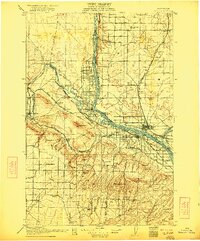
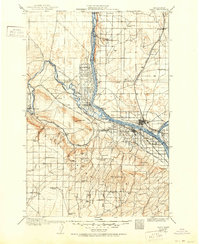
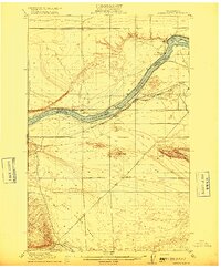
Editions of this 1917 Pasco Map
4 editions found
Other maps of this area

1906 · Blalock Island
USGS Topo · 1:125,000

1908 · Blalock Island
USGS Topo · 1:125,000

1908 · Umatilla
USGS Topo · 1:125,000

1915 · Wallulah
USGS Topo · 1:96,000

1915 · Prosser
USGS Topo · 1:125,000

1916 · Connell
USGS Topo · 1:125,000
1916 · Coyote Rapids
USGS Topo · 1:62,500

1917 · Pasco
USGS Topo · 1:125,000

1917 · Prosser
USGS Topo · 1:125,000

1918 · Connell
USGS Topo · 1:125,000