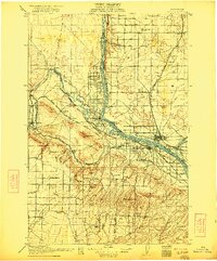
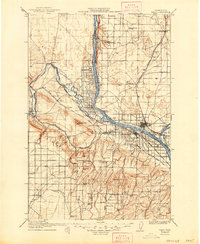
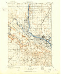
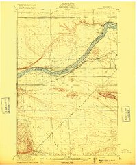
1917 Map of Pasco
USGS Topo · Published 1922About this map
The Columbia River and Yakima River define the development of the Tri-Cities region at a time when irrigation and rail transport were rapidly transforming the desert landscape. While Pasco and Kennewick are established hubs, Richland appears as a smaller settlement long before its mid-century expansion. The landscape is a network of early infrastructure, from the Zimmerman Ferry crossing the Columbia to the extensive Horn Rapids Ditch and various nameless irrigation canals that supported early agriculture. To the south, the Horse Heaven Hills rise above the river valleys, carved by numerous named canyons like Webber Canyon and Badger Canyon. Genealogists can find numerous rural landmarks, including the Triple Springs School, Baxter School, and several family-named water sources such as Bangs Well and Williams Wells.
Find a feature on this map
91 named features on this map. Tap any name to fly to it.
Don’t see what you’re looking for? This feature index may not catch every label — zoom into the map to look around manually.
Map Details
Editions of this 1917 Pasco Map
4 editions found
Other maps of this area

1906 · Blalock Island
USGS Topo · 1:125,000

1908 · Blalock Island
USGS Topo · 1:125,000

1908 · Umatilla
USGS Topo · 1:125,000

1915 · Wallulah
USGS Topo · 1:96,000

1915 · Prosser
USGS Topo · 1:125,000

1916 · Connell
USGS Topo · 1:125,000
1916 · Coyote Rapids
USGS Topo · 1:62,500

1917 · Pasco
USGS Topo · 1:125,000

1917 · Prosser
USGS Topo · 1:125,000

1918 · Connell
USGS Topo · 1:125,000