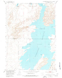
1951 Map of Pathfinder Reservoir NW
USGS Topo · Published 1977About this map
Pathfinder Reservoir dominates this high-altitude Wyoming landscape, where the waters of the North Platte River are impounded within a complex of granite peaks and wildlife sanctuaries. This 1951 survey, part of the Missouri River Basin development program, details the intersection of Natrona and Carbon counties along the reservoir's western reaches. The terrain is defined by dramatic elevation changes, notably Pathfinder Mountain and the jagged spine of Granite Ridge. The map documents the extensive Pathfinder National Wildlife Refuge, tracing the Wildlife Refuge Boundary across a network of points and inlets including Bishop Point and Woolf Point. Geodetic control is anchored by the VABM Pathfinder 6714 station, while drainage like Arkansas Creek feeds into the blue expanse of the high-desert basin.
Find a feature on this map
12 named features on this map. Tap any name to fly to it.
Don’t see what you’re looking for? This feature index may not catch every label — zoom into the map to look around manually.
Map Details
Editions of this 1951 Pathfinder Reservoir NW Map
3 editions found
Other maps of this area

1951 · Benton Basin SW
USGS Topo · 1:24,000

1951 · Benton Basin
USGS Topo · 1:24,000

1951 · Pathfinder Reservoir NW
USGS Topo · 1:24,000

1951 · Pathfinder Dam
USGS Topo · 1:24,000

1951 · Fort Ridge
USGS Topo · 1:24,000

1953 · Leo
USGS Topo · 1:24,000

1953 · Pathfinder Reservoir SW
USGS Topo · 1:24,000

1953 · Buzzard Ranch
USGS Topo · 1:24,000

1955 · Casper
USGS Topo · 1:250,000

1958 · Casper
USGS Topo · 1:250,000