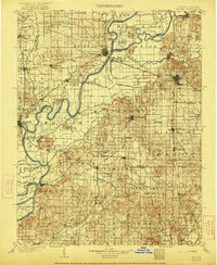
1903 Map of Patoka
USGS Topo · Published 1921About this map
The Wabash River and White River converge in this early century study of the Illinois-Indiana borderlands. The landscape is defined by its complex waterway systems, where the Patoka River meets the larger rivers amidst a network of drainage infrastructure like the Mc. Carty Ditch and Blair Ditch. Major rail junctions at Mount Carmel and Princeton serve as industrial hubs, connecting the Southern RR and the Evansville and Terre Haute RR.
Find a feature on this map
126 named features on this map. Tap any name to fly to it.
Don’t see what you’re looking for? This feature index may not catch every label — zoom into the map to look around manually.
Map Details
Editions of this 1903 Patoka Map
2 editions found
Other maps of this area

1901 · Princeton
USGS Topo · 1:62,500

1901 · Haubstadt
USGS Topo · 1:62,500

1902 · Ditney
USGS Topo · 1:125,000

1902 · Boonville
USGS Topo · 1:62,500

1903 · Haubstadt
USGS Topo · 1:62,500

1903 · New Harmony
USGS Topo · 1:62,500

1903 · Petersburg
USGS Topo · 1:62,500

1903 · Princeton
USGS Topo · 1:62,500

1903 · Patoka
USGS Topo · 1:125,000

1904 · Mount Carmel
USGS Topo · 1:62,500