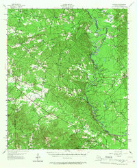
1956 Map of Patroon
USGS Topo · Published 1967About this map
The Sabine River carves a complex path through this East Texas landscape, forming a dense network of sloughs and oxbow lakes like Horseshoe Slough and Soldier Slough. The terrain is defined by the heavy timber of the Sabine National Forest, where small settlements and crossroads like Patroon and Ragtown are linked by winding roads through the Melloci Hills. This mid-century survey reflects a rural society deeply rooted in its local institutions, evidenced by the numerous country churches and cemeteries such as New Jerusalem Ch and Bell Cem scattered across the ridges.
Find a feature on this map
102 named features on this map. Tap any name to fly to it.
Don’t see what you’re looking for? This feature index may not catch every label — zoom into the map to look around manually.
Map Details
Editions of this 1956 Patroon Map
4 editions found

Other maps of this area

1941 · Zwolle
USGS Topo · 1:62,500

1941 · Pelican
USGS Topo · 1:62,500

1943 · Pleasant Hill
USGS Topo · 1:62,500

1944 · Negreet
USGS Topo · 1:62,500

1944 · Logansport
USGS Topo · 1:62,500

1944 · Patroon
USGS Topo · 1:62,500

1944 · Zwolle
USGS Topo · 1:62,500

1944 · Pleasant Hill
USGS Topo · 1:62,500

1953 · Alexandria
USGS Topo · 1:250,000

1953 · Palestine
USGS Topo · 1:250,000