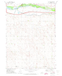
1971 Map of Paxton SW
USGS Topo · Published 1974About this map
The South Platte River corridor dominates this 1970s landscape, serving as a critical artery for both transport and water management. Infrastructure defining the river valley includes the Union Pacific railroad and the South Platte Supply Canal, which run parallel to the waterway. A major focal point for regional water engineering is the Korty Diversion Dam, supported by a nearby Gaging Station and Substation.
Find a feature on this map
10 named features on this map. Tap any name to fly to it.
Don’t see what you’re looking for? This feature index may not catch every label — zoom into the map to look around manually.
Map Details
Editions of this 1971 Paxton SW Map
This is the sole edition of this map. No revisions or reprints were ever made.
Other maps of this area

1897 · Ogallala
USGS Topo · 1:125,000

1898 · Paxton
USGS Topo · 1:125,000

1900 · Ogallala
USGS Topo · 1:125,000

1901 · Paxton
USGS Topo · 1:125,000

1954 · McCook
USGS Topo · 1:250,000

1954 · North Platte
USGS Topo · 1:250,000

1956 · North Platte
USGS Topo · 1:250,000

1957 · North Platte
USGS Topo · 1:250,000

1957 · McCook
USGS Topo · 1:250,000

1958 · McCook
USGS Topo · 1:250,000