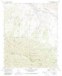
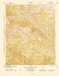
1964 Map of Peak Mountain
USGS Topo · Published 1989About this map
The Cuyama Valley (Heirs of Cesario Lataillade) dominates the northern landscape of this map, representing a significant historical land grant legacy in Santa Barbara County. This high-desert region is defined by the ephemeral Cuyama River and a network of deep drainage systems including Richardson Canyon, Deadman Canyon, and Schoolhouse Canyon. To the south, the terrain rises sharply into the Sierra Madre Mountains, where Peak Mountain and McPherson Peak anchor the ridgeline within the Los Padres National Forest. The presence of numerous water sources such as Richardson Spring, Heath Spring, and Bitter Creek Spring highlights the critical importance of water management in this arid environment. The map details a mix of livestock ranching and early petroleum exploration, evidenced by Caliente Ranch, isolated wells, and a pipeline cutting across the valley floor. Recreational and utility features like the Aliso Campground, Hog Pen Campground, and a Landing Strip further indicate the remote yet managed nature of this wilderness edge during the mid-20th century.
Find a feature on this map
50 named features on this map. Tap any name to fly to it.
Don’t see what you’re looking for? This feature index may not catch every label — zoom into the map to look around manually.
Map Details
Editions of this 1964 Peak Mountain Map
4 editions found
Other maps of this area

1902 · Santa Ynez
USGS Topo · 1:125,000

1905 · Santa Ynez
USGS Topo · 1:125,000

1912 · McKittrick
USGS Topo · 1:125,000

1941 · Caliente Mountain
USGS Topo · 1:62,500

1941 · McPherson Peak
USGS Topo · 1:62,500

1942 · Caliente Mtn
USGS Topo · 1:62,500

1943 · McPherson Peak
USGS Topo · 1:62,500

1943 · Caliente Mtn.
USGS Topo · 1:62,500

1943 · Cuyama Ranch
USGS Topo · 1:31,680
1944 · Salisbury Potrero
USGS Topo · 1:31,680