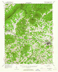
1950 Map of Peaks of Otter
USGS Topo · Published 1964About this map
The Jefferson National Forest dominates the northern half of this landscape, where the Blue Ridge Parkway and Appalachian Trail wind past prominent peaks like Sharp Top Mtn and Flat Top Mtn. Below the mountains, the Norfolk and Western railway corridor serves as a backbone for commerce and travel, connecting communities like Montvale, Thaxton, and the county seat at Bedford.
Find a feature on this map
90 named features on this map. Tap any name to fly to it.
Don’t see what you’re looking for? This feature index may not catch every label — zoom into the map to look around manually.
Map Details
Editions of this 1950 Peaks of Otter Map
5 editions found

Other maps of this area

1890 · Roanoke
USGS Topo · 1:125,000

1891 · Roanoke
USGS Topo · 1:125,000

1892 · Lynchburg
USGS Topo · 1:125,000

1894 · Natural Bridge
USGS Topo · 1:125,000

1894 · Lexington
USGS Topo · 1:125,000

1894 · Natural Bridge
USGS Topo · 1:62,500

1907 · Natural Bridge Special
USGS Topo · 1:62,500

1913 · Eagle Rock
USGS Topo · 1:48,000

1915 · Eagle Rock
USGS Topo · 1:62,500

1929 · Roanoke
USGS Topo · 1:48,000