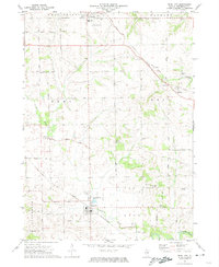
1971 Map of Pearl City
USGS Topo · Published 1974About this map
Pearl City and Lena anchor this agricultural landscape in northwestern Illinois during the early 1970s. The region is characterized by a dense network of sectional roads and the prominent path of the Chicago and North Western railroad, which cuts through the southern townships of Jefferson and Loran. The map captures a high concentration of small family and community burial grounds, such as Babbs Grove Cem and Liebhart Cem, which are often located near the winding course of Yellow Creek.
Find a feature on this map
44 named features on this map. Tap any name to fly to it.
Don’t see what you’re looking for? This feature index may not catch every label — zoom into the map to look around manually.
Map Details
Editions of this 1971 Pearl City Map
This is the sole edition of this map. No revisions or reprints were ever made.
Other maps of this area

1937 · Lena
USGS Topo · 1:48,000

1939 · Freeport
USGS Topo · 1:48,000

1942 · Mt Carroll
USGS Topo · 1:62,500

1942 · Lena
USGS Topo · 1:62,500

1942 · Forreston
USGS Topo · 1:62,500

1943 · Lena
USGS Topo · 1:62,500

1944 · Mt Carroll
USGS Topo · 1:62,500

1944 · Freeport
USGS Topo · 1:62,500

1945 · Forreston
USGS Topo · 1:62,500

1954 · Rockford
USGS Topo · 1:250,000