
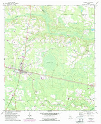
1971 Map of Pearson
USGS Topo · Published 1974About this map
The city of Pearson serves as the focal point of this 1970s survey, situated at the intersection of a developing road network and the Seaboard Coast Line railroad. The surrounding landscape of Atkinson and Coffee counties is characterized by a mix of wetlands and river drainage systems, most notably Ricketson Bay and the winding Satilla River. The land use pattern reveals a transition from the structured street grid of the town to the more dispersed rural layout of the coastal plain.
Find a feature on this map
26 named features on this map. Tap any name to fly to it.
Don’t see what you’re looking for? This feature index may not catch every label — zoom into the map to look around manually.
Map Details
Editions of this 1971 Pearson Map
2 editions found
Other maps of this area

1953 · Waycross
USGS Topo · 1:250,000

1958 · Waycross
USGS Topo · 1:250,000

1968 · Cogdell
USGS Topo · 1:24,000

1971 · Douglas South
USGS Topo · 1:24,000

1971 · Wilsonville
USGS Topo · 1:24,000

1971 · Axson
USGS Topo · 1:24,000

1972 · Kirkland
USGS Topo · 1:24,000

1972 · Sandy Bottom
USGS Topo · 1:24,000

1972 · Henderson Still
USGS Topo · 1:24,000

1972 · Mora
USGS Topo · 1:24,000