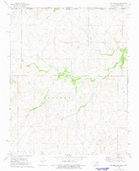
1973 Map of Pearsonia NW
USGS Topo · Published 1975About this map
The Indian Oklahoma Reservation Boundary cuts across this northern Oklahoma landscape, marking a significant historical administrative line just south of the Chautauqua County, Kansas, border. The terrain is defined by the winding course of the Caney River and its numerous tributaries, including Possum Trot Creek and Buck Creek. This area within the Foraker region shows a sparse settlement pattern typical of the Osage Hills, where the land is primarily used for ranching and resource extraction. Evidence of the region’s economic history is visible through scattered Oil Wells, particularly near Dry Creek. The map documents a rural environment where drainage patterns like those of Smith Creek and Pond Creek dictate the layout of unimproved roads and sectional boundaries in Harrison township.
Find a feature on this map
11 named features on this map. Tap any name to fly to it.
Don’t see what you’re looking for? This feature index may not catch every label — zoom into the map to look around manually.
Map Details
Editions of this 1973 Pearsonia NW Map
This is the sole edition of this map. No revisions or reprints were ever made.
Other maps of this area

1885 · Sedan
USGS Topo · 1:125,000

1889 · Burden
USGS Topo · 1:125,000

1889 · Sedan
USGS Topo · 1:125,000

1909 · Pawhuska
USGS Topo · 1:125,000

1910 · Pawhuska
USGS Topo · 1:125,000

1916 · Foraker
USGS Topo · 1:62,500

1955 · Wichita
USGS Topo · 1:250,000

1955 · Enid
USGS Topo · 1:250,000

1958 · Enid
USGS Topo · 1:250,000

1958 · Wichita
USGS Topo · 1:250,000