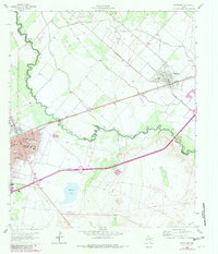
1963 Map of Pecos East
USGS Topo · Published 1981About this map
The Pecos River carves a winding path through this West Texas landscape, serving as the historical boundary between Ward Co and Reeves Co. The community of Pecos is shown during a period of transition, with its established street grid and prominent landmarks like the Pecos School, Bessie Haynes Park, and St Marys Ch anchored near the Missouri Pacific railroad. To the northeast, the smaller settlement of Barstow sits along the same rail line, surrounded by an intricate irrigation system including the Main Line Canal and multiple laterals, illustrating the region's reliance on managed water for agriculture.
Find a feature on this map
39 named features on this map. Tap any name to fly to it.
Don’t see what you’re looking for? This feature index may not catch every label — zoom into the map to look around manually.
Map Details
Editions of this 1963 Pecos East Map
2 editions found
Other maps of this area

1921 · Toyah
USGS Topo · 1:125,000

1931 · Barstow
USGS Topo · 1:125,000

1954 · Pecos
USGS Topo · 1:250,000

1957 · Pecos
USGS Topo · 1:250,000

1961 · Soda Lake
USGS Topo · 1:24,000

1961 · Sand Lake
USGS Topo · 1:24,000

1963 · Old X Ranch
USGS Topo · 1:24,000

1963 · Quito Draw
USGS Topo · 1:24,000

1963 · Pecos East
USGS Topo · 1:24,000

1963 · Toyah Lake
USGS Topo · 1:24,000