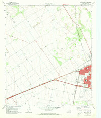
1971 Map of Pecos West
USGS Topo · Published 1973About this map
Pecos stands as a vital West Texas hub in the early 1970s, defined by its intersection of major transportation corridors and municipal infrastructure. The town layout is anchored by the Atchison Topeka and Santa Fe and the Texas, Pacific, and railroads, which facilitated the region's shipping and transit needs. The grid of the West Pecos Sub and streets such as Veterans Blvd and Stafford Blvd show the community's residential and commercial core during this era.
Find a feature on this map
29 named features on this map. Tap any name to fly to it.
Don’t see what you’re looking for? This feature index may not catch every label — zoom into the map to look around manually.
Map Details
Editions of this 1971 Pecos West Map
2 editions found
Other maps of this area

1921 · Toyah
USGS Topo · 1:125,000

1931 · Barstow
USGS Topo · 1:125,000

1954 · Pecos
USGS Topo · 1:250,000

1957 · Pecos
USGS Topo · 1:250,000

1961 · Soda Lake
USGS Topo · 1:24,000

1961 · Sand Lake
USGS Topo · 1:24,000

1963 · Pecos East
USGS Topo · 1:24,000

1963 · Toyah Lake
USGS Topo · 1:24,000

1968 · Mentone SW
USGS Topo · 1:24,000

1970 · Hermosa SW
USGS Topo · 1:24,000