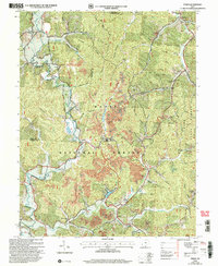
2002 Map of Pedro
USGS Topo · Published 2006About this map
The hills of Wayne National Forest dominate this landscape, where the confluence of numerous hollows and ridges dictates the placement of Lawrence County’s early settlements and industries. In the valley of Pine Creek, the community of Superior sits alongside extensive clay pits, highlighting the importance of refractory manufacturing and mineral extraction in the region's economy. Further south, the map reveals the town of Pedro and the Lawco Lake reservoir, while smaller hamlets like Bondclay and Center Station remain connected by winding routes like Furnace Road. Local education and faith are represented by landmarks such as the Township Sch, Rock Hill School, and Mt Hope Ch, which served the families living along Howard Ridge and Wolcott Ridge in the early 2000s.
Find a feature on this map
85 named features on this map. Tap any name to fly to it.
Don’t see what you’re looking for? This feature index may not catch every label — zoom into the map to look around manually.
Map Details
Editions of this 2002 Pedro Map
This is the sole edition of this map. No revisions or reprints were ever made.
Other maps of this area

1898 · Ironton
USGS Topo · 1:62,500

1900 · Ironton
USGS Topo · 1:62,500

1911 · Sciotoville
USGS Topo · 1:62,500

1912 · Oak Hill
USGS Topo · 1:62,500

1913 · Sciotoville
USGS Topo · 1:62,500

1926 · Greenup
USGS Topo · 1:48,000

1930 · Greenup
USGS Topo · 1:62,500

1953 · Greenup
USGS Topo · 1:24,000
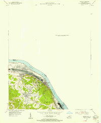
1953 · Ironton
USGS Topo · 1:24,000

1957 · Huntington
USGS Topo · 1:250,000