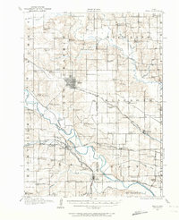
1910 Map of Pella
USGS Topo · Published 1974About this map
Pella serves as the central hub of this 1910 survey, showing the town at a time of significant educational and religious infrastructure across the Iowa countryside. The landscape is densely marked with rural schoolhouses, including the numbered European School No 1, European School No 2, and European School No 3, alongside several others like Bunker Hill School and Battle Ridge School. These small institutions, often just a few miles apart, highlight the localized nature of early twentieth-century rural life in Lake Prairie and surrounding townships.
Find a feature on this map
88 named features on this map. Tap any name to fly to it.
Don’t see what you’re looking for? This feature index may not catch every label — zoom into the map to look around manually.
Map Details
Editions of this 1910 Pella Map
2 editions found
Other maps of this area

1909 · Knoxville
USGS Topo · 1:62,500

1910 · Pella
USGS Topo · 1:62,500

1912 · Knoxville
USGS Topo · 1:62,500

1912 · Pella
USGS Topo · 1:62,500

1924 · Melcher
USGS Topo · 1:62,500

1929 · Albia
USGS Topo · 1:62,500

1954 · Des Moines
USGS Topo · 1:250,000

1956 · Des Moines
USGS Topo · 1:250,000

1957 · Des Moines
USGS Topo · 1:250,000

1965 · Monroe
USGS Topo · 1:24,000