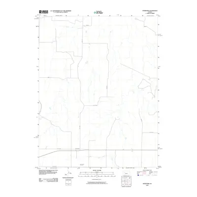
2009 Map of Pendennis
USGS Topo · Published 2009About this map
Pendennis occupies a central role in this portion of Lane County, positioned along a primary east-west transportation corridor. The landscape is defined by the drainage systems of the Smoky Hill River in the north and Wild Horse Creek in the south, which together shape the local topography. This 2009 survey illustrates a high-plains region organized by a rigorous section-line road network, where local routes carry names like Red Chief, Tomahawk, and Wichita. A key point for genealogical research is White Rock Cemetery, located south of the main settlement area. The map details a rural environment where land management is reflected in the numerous county and Gove County roads, such as Gove 63 and Co Rd 260, which connect the scattered agricultural operations across the Kansas prairie.
Find a feature on this map
15 named features on this map. Tap any name to fly to it.
Don’t see what you’re looking for? This feature index may not catch every label — zoom into the map to look around manually.
Map Details
Editions of this 2009 Pendennis Map
This is the sole edition of this map. No revisions or reprints were ever made.
Other maps of this area

1955 · Scott City
USGS Topo · 1:250,000

1958 · Scott City
USGS Topo · 1:250,000

1965 · Utica SW
USGS Topo · 1:24,000

1974 · Gove SW
USGS Topo · 1:24,000

1974 · Gove SE
USGS Topo · 1:24,000

1974 · Castle Rock
USGS Topo · 1:24,000

1974 · Shields NW
USGS Topo · 1:24,000

1974 · Pendennis
USGS Topo · 1:24,000

1974 · Shields SE
USGS Topo · 1:24,000
1974 · Shields
USGS Topo · 1:24,000