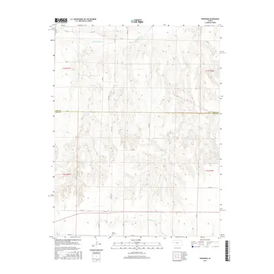
2015 Map of Pendennis
USGS Topo · Published 2015About this map
Pendennis serves as the primary focal point of this high-plains landscape, situated along a prominent east-west transportation corridor. The terrain is defined by the drainage systems of the Smoky Hill River in the north and Wild Horse Cr to the south, showcasing the characteristic eroded breaks of western Kansas. Cultural landmarks like White Rock Cem offer specific touchpoints for local genealogy, while the grid of county roads—including uniquely named routes such as Tomahawk, Wichita, and Scout—reflects the systematic 19th-century land division that persists into the modern era. The boundary between Gove Co and Lane Co bisects the sheet, illustrating how jurisdictional lines follow the section-line roads in this agrarian environment.
Find a feature on this map
26 named features on this map. Tap any name to fly to it.
Don’t see what you’re looking for? This feature index may not catch every label — zoom into the map to look around manually.
Map Details
Editions of this 2015 Pendennis Map
This is the sole edition of this map. No revisions or reprints were ever made.
Other maps of this area

1955 · Scott City
USGS Topo · 1:250,000

1958 · Scott City
USGS Topo · 1:250,000

1965 · Utica SW
USGS Topo · 1:24,000

1974 · Gove SW
USGS Topo · 1:24,000

1974 · Gove SE
USGS Topo · 1:24,000

1974 · Castle Rock
USGS Topo · 1:24,000

1974 · Shields NW
USGS Topo · 1:24,000

1974 · Pendennis
USGS Topo · 1:24,000

1974 · Shields SE
USGS Topo · 1:24,000
1974 · Shields
USGS Topo · 1:24,000