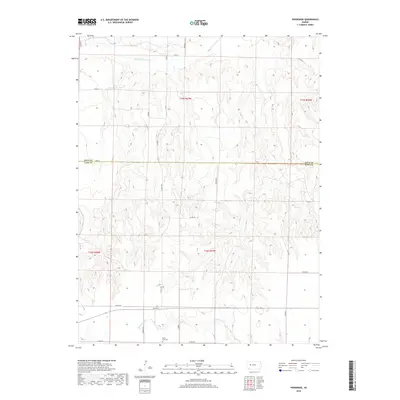
2018 Map of Pendennis
USGS Topo · Published 2018About this map
Pendennis occupies a small footprint in the southern portion of this High Plains landscape, situated along a primary east-west road corridor just south of the Gove County line. The topography is defined by the drainage systems of the Smoky Hill River to the north and the winding path of Wild Horse Cr to the south. This area illustrates the grid-based land division of western Kansas, where section lines are often mirrored by a network of county roads such as Co RD 250 and Co RD 260. Near the settlement, the White Rock Cem provides a specific point of interest for genealogists researching family ties to this rural Lane County community. The map also records localized place names like Tomahawk and Scout, reflecting the area's frontier-influenced heritage.
Find a feature on this map
24 named features on this map. Tap any name to fly to it.
Don’t see what you’re looking for? This feature index may not catch every label — zoom into the map to look around manually.
Map Details
Editions of this 2018 Pendennis Map
This is the sole edition of this map. No revisions or reprints were ever made.
Other maps of this area

1955 · Scott City
USGS Topo · 1:250,000

1958 · Scott City
USGS Topo · 1:250,000

1965 · Utica SW
USGS Topo · 1:24,000

1974 · Gove SW
USGS Topo · 1:24,000

1974 · Gove SE
USGS Topo · 1:24,000

1974 · Castle Rock
USGS Topo · 1:24,000

1974 · Shields NW
USGS Topo · 1:24,000

1974 · Pendennis
USGS Topo · 1:24,000

1974 · Shields SE
USGS Topo · 1:24,000
1974 · Shields
USGS Topo · 1:24,000