
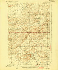
1941 Map of Pendroy
USGS Topo · Published 1941About this map
Pendroy and Dupuyer anchor this Montana landscape, surveyed in the late 1930s at the interface of the Rocky Mountain foothills and the High Plains. The Great Northern railway line terminates in this area, illustrating the limit of rail expansion in north-central Montana. The terrain is defined by a series of branching waterways including the Marias River, Dupuyer Creek, and Farmers Coulee, which supported a network of early cattle operations such as the Soberup Ranch and Armstrong Ranch.
Find a feature on this map
43 named features on this map. Tap any name to fly to it.
Don’t see what you’re looking for? This feature index may not catch every label — zoom into the map to look around manually.
Map Details
Editions of this 1941 Pendroy Map
2 editions found
Other maps of this area

1903 · Saypo
USGS Topo · 1:125,000

1914 · Heart Butte
USGS Topo · 1:125,000

1918 · Heart Butte
USGS Topo · 1:125,000

1920 · Choteau
USGS Topo · 1:125,000

1920 · Dupuyer
USGS Topo · 1:125,000

1934 · Lake Frances
USGS Topo · 1:48,000

1934 · Valier
USGS Topo · 1:62,500

1936 · Pendroy
USGS Topo · 1:48,000

1937 · Valier
USGS Topo · 1:62,500

1937 · Lake Frances
USGS Topo · 1:62,500
Featured Places
- Pendroy, MT
- Rockport Hutterite Colony, MT
- Pondera Hutterite Colony, MT
- Birch Creek Hutterite Colony, MT
- New Miami Hutterite Colony, MT