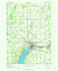
1942 Map of Penn Yan
USGS Topo · Published 1960About this map
Penn Yan serves as the focal point of this 1942 survey, situated at the northern tip of Keuka Lake. The village shows a dense street grid and industrial footprint concentrated along the Outlet, which flows eastward toward Seneca Lake. This waterway supported a history of local industry, evidenced by the downstream settlements of Seneca Mills and Milo Mills. The surrounding landscape of Yates County is divided into the townships of Benton, Milo, Torrey, Jerusalem, and Potter, where a high density of rural schools, such as School No 9 and School No 11, points to a well-distributed agrarian population.
Find a feature on this map
40 named features on this map. Tap any name to fly to it.
Don’t see what you’re looking for? This feature index may not catch every label — zoom into the map to look around manually.
Map Details
Editions of this 1942 Penn Yan Map
4 editions found
Other maps of this area

1902 · Geneva
USGS Topo · 1:62,500

1902 · Phelps
USGS Topo · 1:62,500

1902 · Ovid
USGS Topo · 1:62,500

1903 · Penn Yan
USGS Topo · 1:62,500

1942 · Penn Yan
USGS Topo · 1:31,680

1942 · Pulteney
USGS Topo · 1:31,680

1942 · Rushville
USGS Topo · 1:31,680

1942 · Potter
USGS Topo · 1:31,680

1942 · Stanley
USGS Topo · 1:31,680

1942 · Dundee
USGS Topo · 1:24,000