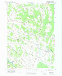
1956 Map of Pennellville
USGS Topo · Published 1975About this map
The Oswego River and Oswego Canal carve through the southwestern corner of this Oswego County landscape, marking a vital corridor of New York's historic water-based transport network. Inland from the river, the mid-1950s terrain is a patchwork of small agricultural settlements and crossroads, including Pennellville, Gilbert Mills, and Palermo. The infrastructure of the era is clearly defined by the diverging paths of the New York Central and the New York Ontario and Western railroads, which once serviced industrial points like Great Bear Siding.
Find a feature on this map
56 named features on this map. Tap any name to fly to it.
Don’t see what you’re looking for? This feature index may not catch every label — zoom into the map to look around manually.
Map Details
Editions of this 1956 Pennellville Map
4 editions found
Other maps of this area

1895 · Syracuse
USGS Topo · 1:62,500

1898 · Syracuse
USGS Topo · 1:62,500

1900 · Baldwinsville
USGS Topo · 1:62,500

1900 · Fulton
USGS Topo · 1:62,500

1905 · Mexico
USGS Topo · 1:62,500

1940 · Brewerton
USGS Topo · 1:24,000

1943 · Oswego East
USGS Topo · 1:31,680

1943 · Lysander
USGS Topo · 1:31,680

1943 · New Haven
USGS Topo · 1:31,680

1943 · Brewerton
USGS Topo · 1:31,680