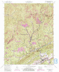
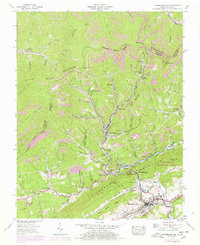
1955 Map of Pennington Gap
USGS Topo · Published 1991About this map
Little Black Mountain and Lone Mountain dominate this Central Appalachian terrain, where the economy of the mid-1950s is defined by coal production and rail transport. Extensive strip mines are etched into the hillsides above company towns and mining settlements like Bonny Blue, St Charles, and Darbyville. This map reveals the dense settlement patterns typical of the era's mining districts, where small communities were tightly clustered near the work sites and connected by rail spurs like Turners Siding. In the valley floor, the Powell River and North Fork Powell River converge near Pennington Gap, the regional center. Numerous family and community landmarks, including Belcher Chapel, Rocklick Ch, and the Napier Cem, offer significant details for genealogists tracing family roots in Lee and Harlan counties along the Kentucky Virginia border.
Find a feature on this map
45 named features on this map. Tap any name to fly to it.
Don’t see what you’re looking for? This feature index may not catch every label — zoom into the map to look around manually.
Map Details
Editions of this 1955 Pennington Gap Map
5 editions found
Other maps of this area

1887 · Jonesville
USGS Topo · 1:125,000

1891 · Jonesville
USGS Topo · 1:125,000

1894 · Estillville
USGS Topo · 1:125,000

1916 · Nolansburg
USGS Topo · 1:48,000

1919 · Nolansburg
USGS Topo · 1:62,500

1921 · Big Stone Gap
USGS Topo · 1:48,000

1922 · Big Stone Gap
USGS Topo · 1:62,500

1929 · Big Stone Gap
USGS Topo · 1:62,500

1935 · Hubbard Springs
USGS Topo · 1:24,000
1935 · Evarts
USGS Topo · 1:24,000