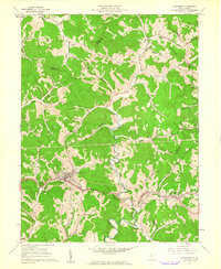
1961 Map of Pennsboro
USGS Topo · Published 1962About this map
Pennsboro sits as the central hub of this Ritchie County landscape, where the Baltimore and Ohio RR follows the winding path of the North Fork Hughes River. The 1961 survey reveals a territory deeply integrated with the energy industry of the era, marked by numerous Gas Wells and Oil Wells scattered across the ridges of Clay and Meade districts. The Telephone Line tracks parallel to the railroad, connecting small settlements like Toll Gate, Greenwood, and Duckworth in the southern valley.
Find a feature on this map
51 named features on this map. Tap any name to fly to it.
Don’t see what you’re looking for? This feature index may not catch every label — zoom into the map to look around manually.
Map Details
Editions of this 1961 Pennsboro Map
4 editions found
Other maps of this area

1905 · West Union
USGS Topo · 1:62,500

1906 · Saint Marys
USGS Topo · 1:62,500

1906 · Holbrook
USGS Topo · 1:62,500

1907 · Harrisville
USGS Topo · 1:62,500

1924 · St Marys
USGS Topo · 1:62,500

1924 · Harrisville
USGS Topo · 1:62,500

1924 · West Union
USGS Topo · 1:62,500

1924 · Holbrook
USGS Topo · 1:62,500

1926 · Harrisville
USGS Topo · 1:62,500

1926 · Holbrook
USGS Topo · 1:62,500