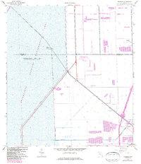
1963 Map of Pennsuco
USGS Topo · Published 1984About this map
The Everglades Wildlife Management Area No. 3 dominates the western half of this Florida landscape, defined by vast stretches of water impounded for conservation and flood control. Along the diagonal course of the Miami Canal, a network of infrastructure including a Gaging Sta, several Control Gate locations, and a Boat Ramp illustrates the intensive water management efforts of the era.
Find a feature on this map
25 named features on this map. Tap any name to fly to it.
Don’t see what you’re looking for? This feature index may not catch every label — zoom into the map to look around manually.
Map Details
Editions of this 1963 Pennsuco Map
4 editions found
Other maps of this area

1949 · Opalocka
USGS Topo · 1:24,000

1950 · Hialeah
USGS Topo · 1:24,000

1956 · Miami
USGS Topo · 1:250,000

1956 · West Palm Beach
USGS Topo · 1:250,000

1957 · West Palm Beach
USGS Topo · 1:250,000

1958 · West Palm Beach
USGS Topo · 1:250,000

1958 · Miami
USGS Topo · 1:250,000
1962 · Hialeah
USGS Topo · 1:24,000

1962 · Opa-locka
USGS Topo · 1:24,000

1963 · Pennsuco
USGS Topo · 1:24,000