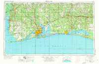
1957 Map of Pensacola
USGS Topo · Published 1973About this map
NAS Pensacola and the sprawling training complexes of NAS Whiting (North) and NAS Whiting (South) anchor the coastal defense landscape of the Florida Panhandle and southern Alabama. This mid-century survey captures the region's intense military footprint, from the massive Eglin Air Force Base in the east to the strategic shoreline of Santa Rosa Island. The transition from the developed waterfronts of Pensacola and Fort Walton Beach to the dense woodlands of the Blackwater River State Forest highlights the dual nature of the Gulf Coast as both a tactical hub and a natural resource.
Find a feature on this map
50 named features on this map. Tap any name to fly to it.
Don’t see what you’re looking for? This feature index may not catch every label — zoom into the map to look around manually.
Map Details
Editions of this 1957 Pensacola Map
3 editions found

Other maps of this area

1920 · Milton
USGS Topo · 1:62,500

1920 · Robertsdale
USGS Topo · 1:62,500

1921 · Holley
USGS Topo · 1:62,500

1921 · Bon Secour
USGS Topo · 1:62,500

1921 · Pensacola
USGS Topo · 1:62,500

1921 · Point Clear
USGS Topo · 1:62,500

1921 · Fairhope
USGS Topo · 1:62,500

1921 · Dauphin Island
USGS Topo · 1:62,500

1921 · Fort Barrancas
USGS Topo · 1:62,500

1921 · Muscogee
USGS Topo · 1:62,500