
1946 Map of Penuelas
USGS Topo · Published 1946About this map
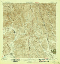
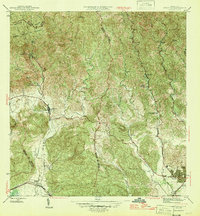
Río Tallaboa and its many tributaries carve through a complex mountainous landscape just before the mid-century period of rapid industrialization in southern Puerto Rico. This map shows the transition from traditional agrarian land use to modern infrastructure, evidenced by the presence of both historical estates like Hacienda Dolores and Hacienda Burenes alongside new energy developments such as Salto Garzas Planta Hidroelectrica No 1. The rail network of the American Railroad of P. R. skirts the southern coastal plains, connecting coastal Tallaboa to the urban fringes of Ponce. Notable educational and social institutions appear in the rural interior, including the Escuela Industrial de Niñas and the Escuela Segunda Unidad de Corral Viejo. Much of the northwestern corner is protected within the Bosque Insular de Guilarte, rising toward landmarks like the Cerrote de Peñuelas.
Find a feature on this map
55 named features on this map. Tap any name to fly to it.
Don’t see what you’re looking for? This feature index may not catch every label — zoom into the map to look around manually.
Map Details
Editions of this 1946 Penuelas Map
3 editions found
Other maps of this area

1945 · Playa De Ponce
USGS Topo · 1:30,000

1945 · Ponce
USGS Topo · 1:30,000

1946 · Punta Cuchara
USGS Topo · 1:30,000

1946 · Yauco
USGS Topo · 1:30,000

1946 · Jayuya
USGS Topo · 1:30,000

1946 · Monte Guilarte
USGS Topo · 1:30,000

1946 · Punta Verraco
USGS Topo · 1:30,000

1946 · Adjuntas
USGS Topo · 1:30,000
1947 · Yauco NE
USGS Topo · 1:10,000

1947 · Punta Gughara NE
USGS Topo · 1:10,000
Featured Places
- Peñuelas
- Sector La Gelpa, Peñuelas
- Sector La Vaquería, Ponce
- Sector Loyola, Peñuelas
- Sector Los Cruz, Ponce