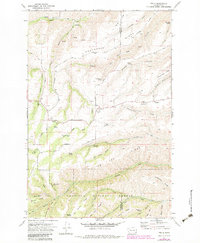
1971 Map of Peola
USGS Topo · Published 1983About this map
The settlement of Peola occupies the high ground of the Garfield and Asotin county line, surrounded by a complex system of ridges and deep-cut drainage gulches. This 1970s landscape is defined by its water sources, with numerous family-named landmarks such as Flerchinger Spring, McGilvra Spring, and Wolf Spring supporting life on these uplands. To the south, the Umatilla National Forest begins, where the terrain drops sharply into the canyons of Lick Creek and Charley Creek. The map records the historical footprint of early pioneers through features like the Pioneer Cemetery and Iron Springs. The intricate network of ridges, including Knotgrass Ridge and Tam Ridge, illustrates the topographic challenges of early regional transportation and ranching before modern development altered these remote stretches of eastern Washington.
Find a feature on this map
54 named features on this map. Tap any name to fly to it.
Don’t see what you’re looking for? This feature index may not catch every label — zoom into the map to look around manually.
Map Details
Editions of this 1971 Peola Map
2 editions found
Other maps of this area

1937 · Pomeroy
USGS Topo · 1:96,000

1942 · Pomeroy
USGS Topo · 1:125,000

1943 · Peola
USGS Topo · 1:62,500

1943 · Saddle Butte
USGS Topo · 1:62,500

1946 · Saddle Butte
USGS Topo · 1:62,500

1946 · Peola
USGS Topo · 1:62,500

1955 · Pullman
USGS Topo · 1:250,000

1958 · Pullman
USGS Topo · 1:250,000

1967 · Rose Springs
USGS Topo · 1:24,000
1967 · Pomeroy
USGS Topo · 1:24,000