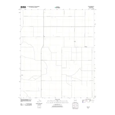
2010 Map of Pep
USGS Topo · Published 2010About this map
Pep and Richland anchor this High Plains landscape in Roosevelt County, characterized by a rigorous grid of section-line roads and scattered agricultural settlements. The terrain is marked by the presence of Richland Cemetery and New Hope Cemetery, which provide important genealogical touchpoints for local family histories. A network of rural routes, including S Roosevelt Road 29 and S Roosevelt Road 32, connects these remote communities across the flat expanse. The geometry of the landscape is defined by this agricultural infrastructure, where nearly every mile is delineated by named thoroughfares like S Roosevelt Road 27 and S Roosevelt Road 33. This 2010 survey from the U.S. Geological Survey documents the rural layout of the region, showing how long-established landmarks like the cemeteries remain focal points in a sparsely populated environment.
Find a feature on this map
18 named features on this map. Tap any name to fly to it.
Don’t see what you’re looking for? This feature index may not catch every label — zoom into the map to look around manually.
Map Details
Editions of this 2010 Pep Map
This is the sole edition of this map. No revisions or reprints were ever made.
Other maps of this area

1954 · Brownfield
USGS Topo · 1:250,000

1958 · Brownfield
USGS Topo · 1:250,000

1962 · Brownfield
USGS Topo · 1:250,000

1972 · Bluit
USGS Topo · 1:24,000

1972 · Dora NW
USGS Topo · 1:24,000

1972 · Garrison
USGS Topo · 1:24,000

1972 · Milnesand
USGS Topo · 1:24,000

1972 · Dora SW
USGS Topo · 1:24,000
1972 · Pep
USGS Topo · 1:24,000
1972 · Causey West
USGS Topo · 1:24,000