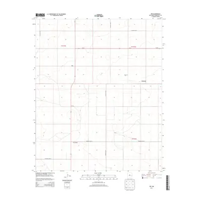
2013 Map of Pep
USGS Topo · Published 2013About this map
The high plains of eastern New Mexico define this region of Roosevelt County, where the small community of Pep serves as a central point in a landscape marked by a rigid grid of ranch and farm roads. The terrain is relatively flat, as indicated by the sparse contour lines, with the local geography organized by the Public Land Survey System. The settlement of Richland lies to the east, anchored by the Richland Cem, a key landmark for genealogical research in this sparsely populated area. Transportation is facilitated by a network of thoroughfares including NM-458 and several numbered county routes such as S Roosevelt Road P and S Roosevelt Road 27. This map documents a quiet agricultural district where the vastness of the Llano Estacado is managed through a precise system of section lines and gravel roads, connecting isolated homesteads to the primary Highway.
Find a feature on this map
14 named features on this map. Tap any name to fly to it.
Don’t see what you’re looking for? This feature index may not catch every label — zoom into the map to look around manually.
Map Details
Editions of this 2013 Pep Map
This is the sole edition of this map. No revisions or reprints were ever made.
Other maps of this area

1954 · Brownfield
USGS Topo · 1:250,000

1958 · Brownfield
USGS Topo · 1:250,000

1962 · Brownfield
USGS Topo · 1:250,000

1972 · Bluit
USGS Topo · 1:24,000

1972 · Dora NW
USGS Topo · 1:24,000

1972 · Garrison
USGS Topo · 1:24,000

1972 · Milnesand
USGS Topo · 1:24,000

1972 · Dora SW
USGS Topo · 1:24,000
1972 · Pep
USGS Topo · 1:24,000
1972 · Causey West
USGS Topo · 1:24,000