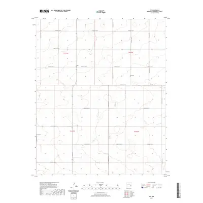
2020 Map of Pep
USGS Topo · Published 2020About this map
Pep and Richland anchor this high plains landscape of Roosevelt County, where a rigid grid of rural routes defines the local geography. The area's social and community history is centered around these modest settlements and the dedicated burial grounds that serve them. Family historians will find interest in the location of Richland Cem south of S Roosevelt Road 29 and New Hope Cem situated along the western edge of the quadrangle. The map reveals the importance of the section-line road system, including North-South connectors like Dora Main St and S Roosevelt Road P, which link the various townships. This 2020 data captures the enduring agricultural character of the region, where the intersection of S Roosevelt Road 30 and the main thoroughfares through Richland continue to form the backbone of the local community.
Find a feature on this map
22 named features on this map. Tap any name to fly to it.
Don’t see what you’re looking for? This feature index may not catch every label — zoom into the map to look around manually.
Map Details
Editions of this 2020 Pep Map
This is the sole edition of this map. No revisions or reprints were ever made.
Other maps of this area

1954 · Brownfield
USGS Topo · 1:250,000

1958 · Brownfield
USGS Topo · 1:250,000

1962 · Brownfield
USGS Topo · 1:250,000

1972 · Bluit
USGS Topo · 1:24,000

1972 · Dora NW
USGS Topo · 1:24,000

1972 · Garrison
USGS Topo · 1:24,000

1972 · Milnesand
USGS Topo · 1:24,000

1972 · Dora SW
USGS Topo · 1:24,000
1972 · Pep
USGS Topo · 1:24,000
1972 · Causey West
USGS Topo · 1:24,000