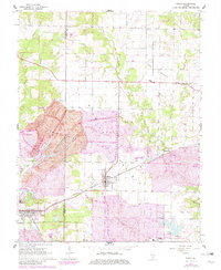
1965 Map of Percy
USGS Topo · Published 1982About this map
Six Mile Prairie and the surrounding southwestern Illinois landscape appear here during a period of transition between agricultural roots and intensive industrial extraction. The twin settlements of Cutler and Percy serve as focal points for the region's transportation network, situated at the confluence of the Missouri Pacific and Illinois Central Gulf railroads. This rail connectivity was vital for the heavy industry visible on the map, particularly the extensive Strip Mine operations and various Pit sites that dominate the western terrain near Lick Branch.
Find a feature on this map
27 named features on this map. Tap any name to fly to it.
Don’t see what you’re looking for? This feature index may not catch every label — zoom into the map to look around manually.
Map Details
Editions of this 1965 Percy Map
3 editions found
Other maps of this area

1910 · Murphysboro
USGS Topo · 1:62,500

1914 · Coulterville
USGS Topo · 1:62,500

1916 · Campbell Hill
USGS Topo · 1:62,500

1917 · Coulterville
USGS Topo · 1:62,500

1918 · Campbell Hill
USGS Topo · 1:62,500

1924 · Pinckneyville
USGS Topo · 1:62,500

1926 · Pinckneyville
USGS Topo · 1:62,500

1938 · Murphysboro
USGS Topo · 1:62,500

1949 · Paducah
USGS Topo · 1:250,000

1950 · Paducah
USGS Topo · 1:250,000