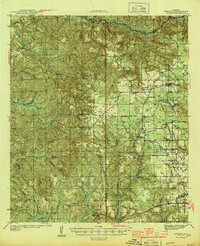
1944 Map of Perdido
USGS Topo · Published 1944About this map
Atmore and Freemanville anchor the southeastern portion of this 1942 survey, where the convergence of the St. Louis San Francisco RR and the Louisville and Nashville RR illustrates the region's mid-century reliance on heavy rail for logistics. The landscape transitions from the developed grids around Nokomis and McCullough to the timber-rich drainages of Little River and Blacksher Creek. Small rural communities like Lottie and Rabun are defined by localized social centers such as the Langham Lottie Sch and Jack Springs Ch.
Find a feature on this map
53 named features on this map. Tap any name to fly to it.
Don’t see what you’re looking for? This feature index may not catch every label — zoom into the map to look around manually.
Map Details
Editions of this 1944 Perdido Map
2 editions found

Other maps of this area

1941 · Bay Minette
USGS Topo · 1:62,500

1941 · Century
USGS Topo · 1:62,500

1942 · Perdido
USGS Topo · 1:62,500

1942 · Dyas
USGS Topo · 1:62,500

1943 · Century
USGS Topo · 1:62,500

1943 · Bay Minette
USGS Topo · 1:62,500

1943 · Choctaw Bluff
USGS Topo · 1:62,500

1943 · Tensaw
USGS Topo · 1:62,500

1944 · Tensaw
USGS Topo · 1:62,500

1944 · Dyas
USGS Topo · 1:62,500