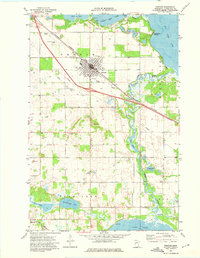
1973 Map of Perham
USGS Topo · Published 1975About this map
Perham serves as the focal point of this 1970s survey, situated between the expansive waters of Little Pine Lake and Big Pine Lake. The town's religious and civic infrastructure is well-defined, featuring St Henry Ch, St Paul Ch, and St Stanislaus Ch, alongside the Perham Cem. Local recreation and entertainment are represented by Lakeside Country Club and a Drive-in Theater west of town near the Perham Municipal Airfield.
Find a feature on this map
43 named features on this map. Tap any name to fly to it.
Don’t see what you’re looking for? This feature index may not catch every label — zoom into the map to look around manually.
Map Details
Editions of this 1973 Perham Map
This is the sole edition of this map. No revisions or reprints were ever made.
Other maps of this area

1912 · Battle Lake
USGS Topo · 1:62,500

1914 · Battle Lake
USGS Topo · 1:62,500

1915 · Perham
USGS Topo · 1:62,500

1953 · Brainerd
USGS Topo · 1:250,000

1957 · Brainerd
USGS Topo · 1:250,000

1958 · Brainerd
USGS Topo · 1:250,000

1965 · Brainerd
USGS Topo · 1:250,000

1969 · New York Mills NW
USGS Topo · 1:24,000

1969 · Heinola
USGS Topo · 1:24,000

1969 · New York Mills West
USGS Topo · 1:24,000