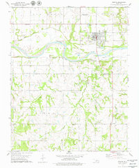
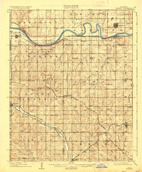
1909 Map of Perkins
USGS Topo · Published 1909About this map
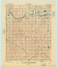
The Cimarron River meanders through a landscape defined by the rapid rail expansion and rural settlement of central Oklahoma just after statehood. This territory, spanning portions of Logan, Payne, and Lincoln Counties, is crisscrossed by a dense network of competing rail lines, including the Atchison Topeka and Santa Fe RR and the Missouri Kansas and Texas RR, which facilitated the growth of towns like Perkins and Coyle. The sheet is remarkable for its concentration of early educational and social landmarks, featuring dozens of country schools such as Eagle College School and Lincoln Park School, alongside the Mt Bethel Church. These small community hubs reflect the homesteading era's social fabric before the consolidation of rural districts. Away from the river, the terrain transitions into the creek-carved uplands of South Cimarron and Paradise, where Wildhorse Creek and Bellcow Creek drain the fertile agricultural lands.
Find a feature on this map
63 named features on this map. Tap any name to fly to it.
Don’t see what you’re looking for? This feature index may not catch every label — zoom into the map to look around manually.
Map Details
Editions of this 1909 Perkins Map
4 editions found

Historical Maps of Perkins Through Time
7 maps found