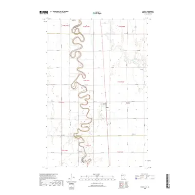
2019 Map of Perley
USGS Topo · Published 2019About this map
The Red River of the North winds in tight, dramatic meanders along the border of Minnesota and North Dakota, defining the western edge of this agricultural landscape. The small settlement of Perley is the primary hub, situated near the intersection of Co Rd 106 and 120th Ave. This area is heavily defined by its Lutheran heritage, visible through several community focal points like the Nora Lutheran Church and its accompanying Nora Lutheran Church Cem. The landscape is a grid of section lines and rural roads, such as Co Rd 4 and 100th Ave, crossing the fertile plains where the Wild Rice River joins the larger drainage system. Genealogists will find significant value in the documentation of local burial sites, including Old Bethlehem Lutheran Cem, Kirkebo Cem, and the Pioneer Cem.
Find a feature on this map
46 named features on this map. Tap any name to fly to it.
Don’t see what you’re looking for? This feature index may not catch every label — zoom into the map to look around manually.
Map Details
Editions of this 2019 Perley Map
This is the sole edition of this map. No revisions or reprints were ever made.
Other maps of this area

1918 · Hendrum
USGS Topo · 1:62,500

1924 · Ada
USGS Topo · 1:62,500

1952 · Grand Forks
USGS Topo · 1:250,000

1956 · Grand Forks
USGS Topo · 1:250,000

1963 · Georgetown
USGS Topo · 1:24,000
1963 · Argusville
USGS Topo · 1:24,000

1963 · Perley
USGS Topo · 1:24,000

1963 · Gardner
USGS Topo · 1:24,000

1963 · Halstad
USGS Topo · 1:24,000

1963 · Halstad SW
USGS Topo · 1:24,000