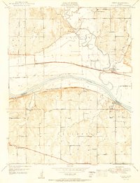
1950 Map of Perry
USGS Topo · Published 1950About this map
The Kansas River valley dominates this mid-century landscape, where the confluence with the Delaware River creates a network of fertile bottomlands and shifting waterways like Slough Cr. The town of Perry serves as a primary rail hub, situated at the junction of the Union Pacific railroad and regional roadways. Further south, the settlement of Lecompton sits on the bluffs overlooking the river, preserving its historical layout near the Lecompton township boundary. This era of Kansas agriculture is marked by a dense grid of rural infrastructure, including many family-named landmarks and local institutions. Genealogists will find a wealth of specific locations such as Big Springs Cem, Glenn Ch, and the Round Mound Sch. The map also preserves the trajectory of the Old Delaware Reservation Boundary, a significant historical line still etched into the property divisions of the 1950s.
Find a feature on this map
32 named features on this map. Tap any name to fly to it.
Don’t see what you’re looking for? This feature index may not catch every label — zoom into the map to look around manually.
Map Details
Editions of this 1950 Perry Map
3 editions found

Other maps of this area

1885 · Lawrence
USGS Topo · 1:125,000

1886 · Oskaloosa
USGS Topo · 1:125,000

1888 · Oskaloosa
USGS Topo · 1:125,000

1889 · Burlingame
USGS Topo · 1:125,000

1889 · Topeka
USGS Topo · 1:125,000

1889 · Lawrence
USGS Topo · 1:125,000

1894 · Burlingame
USGS Topo · 1:125,000

1894 · Oskaloosa
USGS Topo · 1:125,000

1894 · Topeka
USGS Topo · 1:125,000

1947 · Lawrence
USGS Topo · 1:250,000