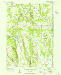
1954 Map of Perrysburg
USGS Topo · Published 1956About this map
Perrysburg serves as a primary hub in this mid-century portrait of Chautauqua County, where the industrial presence of the Erie RR cuts across the northern landscape near Smith Mills. The area is characterized by a high concentration of localized infrastructure, including several numbered rural schools such as School No 4 and School No 6, alongside significant community landmarks like the Memorial Hospital. The terrain is defined by the headwaters of several drainages, most notably Silver Creek and the North Branch Conewango Creek.
Find a feature on this map
54 named features on this map. Tap any name to fly to it.
Don’t see what you’re looking for? This feature index may not catch every label — zoom into the map to look around manually.
Map Details
Editions of this 1954 Perrysburg Map
4 editions found
Other maps of this area

1899 · Silver Creek
USGS Topo · 1:62,500

1900 · Cherry Creek
USGS Topo · 1:62,500

1905 · Eden
USGS Topo · 1:62,500

1907 · Eden
USGS Topo · 1:62,500

1923 · Cattaraugus
USGS Topo · 1:62,500

1938 · Cattaraugus
USGS Topo · 1:62,500

1941 · Cattaraugus
USGS Topo · 1:62,500

1941 · Cherry Creek
USGS Topo · 1:62,500

1943 · Silver Creek
USGS Topo · 1:24,000

1944 · Eden
USGS Topo · 1:62,500