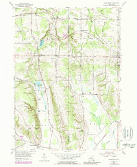
1954 Map of Perrysburg
USGS Topo · Published 1988About this map
The Chautauqua and Cattaraugus county line bisects this landscape of upland plateaus and creek valleys, where small agricultural hamlets like Nashville and Perrysburg serve as local hubs. The northern section is dominated by the drainage of Silver Creek, including the Silver Creek Reservoir, while the southern reaches fall toward the North Branch Conewango Creek. Transportation patterns here were historically shaped by the Erie RR, which tracks through the eastern portion of the map near Markhams. This late-1970s revision, based on earlier 1950s fieldwork, reveals a traditional rural structure maintained by a network of local roads such as Alleghany Rd and Mackinaw Road, and dotted with essential community landmarks like Memorial Hospital and various numbered schoolhouses including School No 8 and School No 4.
Find a feature on this map
51 named features on this map. Tap any name to fly to it.
Don’t see what you’re looking for? This feature index may not catch every label — zoom into the map to look around manually.
Map Details
Editions of this 1954 Perrysburg Map
4 editions found
Other maps of this area

1899 · Silver Creek
USGS Topo · 1:62,500

1900 · Cherry Creek
USGS Topo · 1:62,500

1905 · Eden
USGS Topo · 1:62,500

1907 · Eden
USGS Topo · 1:62,500

1923 · Cattaraugus
USGS Topo · 1:62,500

1938 · Cattaraugus
USGS Topo · 1:62,500

1941 · Cattaraugus
USGS Topo · 1:62,500

1941 · Cherry Creek
USGS Topo · 1:62,500

1943 · Silver Creek
USGS Topo · 1:24,000

1944 · Eden
USGS Topo · 1:62,500