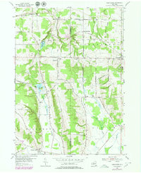
1954 Map of Perrysburg
USGS Topo · Published 1979About this map
Chautauqua and Cattaraugus counties meet along a winding boundary that divides this rural landscape of the mid-1950s. The area is defined by a series of small, interconnected rural communities like Nashville, West Perrysburg, and Smith Mills, each anchored by historical institutions such as School No. 8 and School No. 4. The terrain is deeply carved by water, with Silver Creek and Big Indian Creek flowing through the northern hills toward Lake Erie, while North Branch Conewango Creek drains the southern portion near Villenova.
Find a feature on this map
59 named features on this map. Tap any name to fly to it.
Don’t see what you’re looking for? This feature index may not catch every label — zoom into the map to look around manually.
Map Details
Editions of this 1954 Perrysburg Map
4 editions found
Other maps of this area

1899 · Silver Creek
USGS Topo · 1:62,500

1900 · Cherry Creek
USGS Topo · 1:62,500

1905 · Eden
USGS Topo · 1:62,500

1907 · Eden
USGS Topo · 1:62,500

1923 · Cattaraugus
USGS Topo · 1:62,500

1938 · Cattaraugus
USGS Topo · 1:62,500

1941 · Cattaraugus
USGS Topo · 1:62,500

1941 · Cherry Creek
USGS Topo · 1:62,500

1943 · Silver Creek
USGS Topo · 1:24,000

1944 · Eden
USGS Topo · 1:62,500