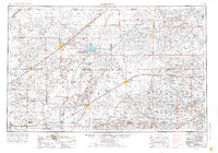
1954 Map of Perryton
USGS Topo · Published 1977About this map
Perryton and Guymon anchor this mid-century survey of the High Plains, spanning the intersections of the Oklahoma Panhandle with neighboring Kansas and Texas. The landscape is defined by the critical drainage basins of the Cimarron River and Beaver River, where the Optima National Wildlife Refuge marks a significant conservation area along the North Fork. The region’s economic foundation in the 1950s is evidenced by numerous gas wells and the extensive rail infrastructure provided by the Atchison Topeka and Santa Fe RR and the Chicago Rock Island and Pacific RR. Beyond the larger grain and cattle hubs, smaller communities like Texhoma, Hooker, and Forgan appear alongside local educational and recreational landmarks such as Goodwell College and Beaver Pioneer State Park. Natural features like the Dunes and Wild Horse Lake provide contrast to the rigid grid of county lines and section roads.
Find a feature on this map
94 named features on this map. Tap any name to fly to it.
Don’t see what you’re looking for? This feature index may not catch every label — zoom into the map to look around manually.
Map Details
Editions of this 1954 Perryton Map
3 editions found
Other maps of this area

1892 · Meade
USGS Topo · 1:125,000

1892 · Vilas
USGS Topo · 1:125,000

1896 · Ashland
USGS Topo · 1:125,000

1953 · Stinnett Station
USGS Topo · 1:24,000

1953 · Pringle
USGS Topo · 1:24,000

1954 · Tucumcari
USGS Topo · 1:250,000

1954 · Perryton
USGS Topo · 1:250,000

1954 · Amarillo
USGS Topo · 1:250,000

1954 · Dalhart
USGS Topo · 1:250,000

1955 · Clinton
USGS Topo · 1:250,000